
Choondal topographic map
Interactive map
Click on the map to display elevation.
About this map
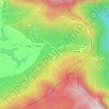
Name: Choondal topographic map, elevation, terrain.
Location: Choondal, Udumbanchola, Idukki District, Kerala, India (10.00129 77.22853 10.04129 77.26853)
Average elevation: 4,639 ft
Minimum elevation: 2,933 ft
Maximum elevation: 6,368 ft
Other topographic maps
Click on a map to view its topography, its elevation and its terrain.
Chempakapara
India > Kerala > Udumbanchola > Chempakappara > Kochukamakshy
Chempakapara, Kochukamakshy, Chempakappara, Udumbanchola, Idukki District, Kerala, India
Average elevation: 2,661 ft
Senapathy
India > Kerala > Udumbanchola
Senapathy, Udumbanchola, Idukki District, Kerala, 685619, India
Average elevation: 3,448 ft
Panniyarkutty
India > Kerala > Udumbanchola > Rajakkaad
Panniyarkutty, Rajakkaad, Udumbanchola, Idukki District, Kerala, 685566, India
Average elevation: 2,375 ft
Anakkara
India > Kerala > Udumbanchola
Anakkara, Udumbanchola, Idukki District, Kerala, India
Average elevation: 3,445 ft