Geolocate

Senapathy topographic map

Interactive map

Click on the map to display elevation.

About this map

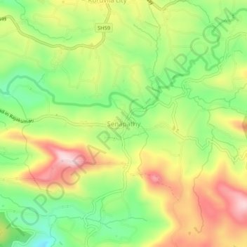
Name: Senapathy topographic map, elevation, terrain.

Location: Senapathy, Udumbanchola, Idukki District, Kerala, 685619, India (9.93074 77.16157 9.97074 77.20157)

Average elevation: 3,448 ft

Minimum elevation: 2,933 ft

Maximum elevation: 4,049 ft

Other topographic maps

Click on a map to view its topography, its elevation and its terrain.

Chempakapara

India > Kerala > Udumbanchola > Chempakappara > Kochukamakshy

Chempakapara, Kochukamakshy, Chempakappara, Udumbanchola, Idukki District, Kerala, India

Average elevation: 2,661 ft

Panniyarkutty

India > Kerala > Udumbanchola > Rajakkaad

Panniyarkutty, Rajakkaad, Udumbanchola, Idukki District, Kerala, 685566, India

Average elevation: 2,375 ft

Choondal

India > Kerala > Udumbanchola

Choondal, Udumbanchola, Idukki District, Kerala, India

Average elevation: 4,639 ft

Anakkara

India > Kerala > Udumbanchola

Anakkara, Udumbanchola, Idukki District, Kerala, India

Average elevation: 3,445 ft