
Make a donation
Gear up for your next adventure:
As an Amazon Associate, this site earns from qualifying purchases at no extra cost to you.
Dammastock topographic map
Click on the map to display elevation.
Make a donation
Gear up for your next adventure:
As an Amazon Associate, this site earns from qualifying purchases at no extra cost to you.
Dammastock
Le Dammastock est le point culminant des Alpes uranaises à 3 631 m d'altitude, à cheval sur les cantons d'Uri et du Valais, en Suisse.
Make a donation
Gear up for your next adventure:
As an Amazon Associate, this site earns from qualifying purchases at no extra cost to you.
About this map
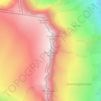
Name: Dammastock topographic map, elevation, terrain.
Location: Dammastock, Göschenen, Uri, 6487, Suisse (46.64340 8.42104 46.64350 8.42114)
Average elevation: 10,295 ft
Minimum elevation: 7,910 ft
Maximum elevation: 11,818 ft
Make a donation
Gear up for your next adventure:
As an Amazon Associate, this site earns from qualifying purchases at no extra cost to you.
Other topographic maps
Click on a map to view its topography, its elevation and its terrain.