
Make a donation
Gear up for your next adventure:
As an Amazon Associate, this site earns from qualifying purchases at no extra cost to you.
Vitte topographic map
Click on the map to display elevation.
Make a donation
Gear up for your next adventure:
As an Amazon Associate, this site earns from qualifying purchases at no extra cost to you.
About this map
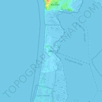
Name: Vitte topographic map, elevation, terrain.
Average elevation: 0 ft
Minimum elevation: -16 ft
Maximum elevation: 92 ft
Make a donation
Gear up for your next adventure:
As an Amazon Associate, this site earns from qualifying purchases at no extra cost to you.
Other topographic maps
Click on a map to view its topography, its elevation and its terrain.
Hiddensee
Deutschland > Mecklenburg-Vorpommern > Vorpommern-Rügen > Insel Hiddensee
Die Insel Hiddensee ist geologisch gesehen eine sehr junge Landschaft und entstand während der letzten Eiszeit vor etwa 12.000 Jahren. Diese hinterließ hier eine Jungmoränenlandschaft. Durch das abtauende Inlandeis hob sich das darunter liegende Land und die Senken füllten sich mit Wasser, der Vorgänger…
Average elevation: 3 ft
Dornbusch
Deutschland > Mecklenburg-Vorpommern > Vorpommern-Rügen > Insel Hiddensee > Kloster
Das gesamte, wenig hügelige Gelände im Südosten besteht teilweise aus Torfablagerungen und einer Grundmoräne. Ganz im Süden dieses Gebiets, östlich vom Hafen von Kloster, erhebt sich eine Stelle noch über das Umland hinaus. Der Höhenzug wird als Schwedenhagen bezeichnet; dies ist ein Hinweis auf eine…
Average elevation: 26 ft