
Thank you for supporting this site ❤️
Make a donation
Make a donation
Gear up for your next adventure:
As an Amazon Associate, this site earns from qualifying purchases at no extra cost to you.
Atacazo topographic map
Click on the map to display elevation.
Thank you for supporting this site ❤️
Make a donation
Make a donation
Gear up for your next adventure:
As an Amazon Associate, this site earns from qualifying purchases at no extra cost to you.
About this map
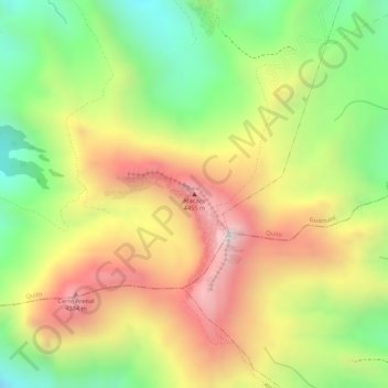
Name: Atacazo topographic map, elevation, terrain.
Location: Atacazo, Lloa, Quito Canton, Pichincha, Ecuador (-0.35356 -78.62156 -0.35346 -78.62146)
Average elevation: 13,494 ft
Minimum elevation: 12,395 ft
Maximum elevation: 14,537 ft
Thank you for supporting this site ❤️
Make a donation
Make a donation
Gear up for your next adventure:
As an Amazon Associate, this site earns from qualifying purchases at no extra cost to you.