
Make a donation
Gear up for your next adventure:
As an Amazon Associate, this site earns from qualifying purchases at no extra cost to you.
Hell-Bourg topographic map
Click on the map to display elevation.
Make a donation
Gear up for your next adventure:
As an Amazon Associate, this site earns from qualifying purchases at no extra cost to you.
About this map
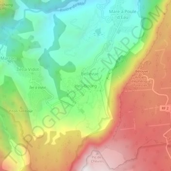
Name: Hell-Bourg topographic map, elevation, terrain.
Location: Hell-Bourg, Salazie, Saint-Benoît, Réunion, 97433, France (-21.08420 55.50226 -21.04420 55.54226)
Average elevation: 3,714 ft
Minimum elevation: 1,765 ft
Maximum elevation: 6,250 ft
Make a donation
Gear up for your next adventure:
As an Amazon Associate, this site earns from qualifying purchases at no extra cost to you.
Other topographic maps
Click on a map to view its topography, its elevation and its terrain.
Lil La Réunion
Already at the time of the India Route or Route des Indes, Réunion was a French possession located between Cape Town and the Indian trading posts, although far from the Mozambique Channel. Isle Bourbon (its name under the Ancien Régime) was not, however, the preferred position for trade and military.…
Average elevation: 1,745 ft
Le Tampon
Le Tampon has an humid subtropical climate (Köppen climate classification: Cwa) at lower elevations and an oceanic climate (Köppen climate classification: Cfb) in Plains des Cafres. The average annual temperature in Le Tampon is 13.8 °C (56.8 °F). The average annual rainfall is 2,020.2 mm (79.54 in) with…
Average elevation: 3,297 ft
La Réunion
Already at the time of the India Route or Route des Indes, Réunion was a French possession located between Cape Town and the Indian trading posts, although far from the Mozambique Channel. Isle Bourbon (its name under the Ancien Régime) was not, however, the preferred position for trade and military.…
Average elevation: 1,745 ft
Make a donation
Gear up for your next adventure:
As an Amazon Associate, this site earns from qualifying purchases at no extra cost to you.
Make a donation
Gear up for your next adventure:
As an Amazon Associate, this site earns from qualifying purchases at no extra cost to you.
Sainte-Rose
Sainte-Rose features a tropical rainforest climate (Köppen Af), with substantial rainfall throughout the course of the year. Its location on the eastern side of Réunion, (windward relative to the trade winds), makes it one of the wettest cities in the world, along with Cherrapunji, Quibdó, and López de…
Average elevation: 1,657 ft
Saint-Denis
The city is located on the north end of the island, and was a port. Saint-Denis was "originally the main port of Réunion, but an artificial harbour at Le Port, on the northwest coast, replaced it in the 1880s, because of unpredictable winds and tides at Saint-Denis." The city includes some of the island's…
Average elevation: 2,369 ft
Réunion
Already at the time of the India Route or Route des Indes, Réunion was a French possession located between Cape Town and the Indian trading posts, although far from the Mozambique Channel. Île de Bourbon (its name under the Ancien Régime) was not, however, the preferred position for trade and military.…
Average elevation: 1,745 ft
Make a donation
Gear up for your next adventure:
As an Amazon Associate, this site earns from qualifying purchases at no extra cost to you.
Le Tampon
Le Tampon has an humid subtropical climate (Köppen climate classification: Cwa) at lower elevations and an oceanic climate (Köppen climate classification: Cfb) in Plains des Cafres. The average annual temperature in Le Tampon is 13.8 °C (56.8 °F). The average annual rainfall is 2,020.2 mm (79.54 in) with…
Average elevation: 3,297 ft