Geolocate

Pasang topographic map

Click on the map to display elevation.

About this map

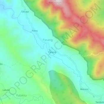
Name: Pasang topographic map, elevation, terrain.

Location: Pasang, Maiwa, Enrekang, South Sulawesi, Sulawesi, Indonesia (-3.63671 119.82435 -3.59671 119.86435)

Average elevation: 1,345 ft

Minimum elevation: 607 ft

Maximum elevation: 2,913 ft

Other topographic maps

Click on a map to view its topography, its elevation and its terrain.

Malua

Indonesia > South Sulawesi > Enrekang

Average elevation: 2,326 ft

Alla

Indonesia > South Sulawesi > Enrekang

Average elevation: 3,402 ft

Baraka

Indonesia > South Sulawesi > Enrekang

Average elevation: 2,713 ft

Buntu Batu

Indonesia > South Sulawesi > Enrekang

Average elevation: 4,787 ft

Bungin

Indonesia > South Sulawesi > Enrekang

Average elevation: 4,062 ft

Cendana

Indonesia > South Sulawesi > Enrekang

Average elevation: 499 ft

Maiwa

Indonesia > South Sulawesi > Enrekang

Average elevation: 702 ft

Malua

Indonesia > South Sulawesi > Enrekang

Average elevation: 2,326 ft

Gear up for your next adventure:

🧤Hiking Gloves - Protective gloves for rugged trails
🧥Men's Rain Shells - Premium waterproof and breathable jackets for mountain weather
🥤Water Filter Bottle - All‑in‑one filter bottle for safe hydration
📌Outdoor GPS Map App - Apps and devices for digital topographic navigation
🩹Survival Bandages - High‑quality bandages for emergencies

As an Amazon Associate, this site earns from qualifying purchases at no extra cost to you.