
Make a donation
Gear up for your next adventure:
As an Amazon Associate, this site earns from qualifying purchases at no extra cost to you.
Tronceda topographic map
Click on the map to display elevation.
Make a donation
Gear up for your next adventure:
As an Amazon Associate, this site earns from qualifying purchases at no extra cost to you.
About this map
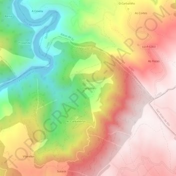
Name: Tronceda topographic map, elevation, terrain.
Average elevation: 2,119 ft
Minimum elevation: 673 ft
Maximum elevation: 3,310 ft
Make a donation
Gear up for your next adventure:
As an Amazon Associate, this site earns from qualifying purchases at no extra cost to you.
Other topographic maps
Click on a map to view its topography, its elevation and its terrain.
Make a donation
Gear up for your next adventure:
As an Amazon Associate, this site earns from qualifying purchases at no extra cost to you.
Santa Tegra de Abeleda
España > Galicia > Tierra de Caldelas > Castro Caldelas
Average elevation: 1,650 ft
Castro Caldelas
España > Galicia > Tierra de Caldelas
El punto más elevado se encuentra en la Pena da Cruz, a 1289 m de altitud, por el contrario encontramos los 230 m a los que se encuentra el río Sil.
Average elevation: 2,625 ft
Make a donation
Gear up for your next adventure:
As an Amazon Associate, this site earns from qualifying purchases at no extra cost to you.
Castro Caldelas
España > Galicia > Tierra de Caldelas
El punto más elevado se encuentra en la Pena da Cruz, a 1289 m de altitud, por el contrario encontramos los 230 m a los que se encuentra el río Sil.
Average elevation: 2,625 ft