
Thank you for supporting this site ❤️
Make a donation
Make a donation
Gear up for your next adventure:
As an Amazon Associate, this site earns from qualifying purchases at no extra cost to you.
Cavaca topographic map
Click on the map to display elevation.
Thank you for supporting this site ❤️
Make a donation
Make a donation
Gear up for your next adventure:
As an Amazon Associate, this site earns from qualifying purchases at no extra cost to you.
About this map
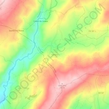
Name: Cavaca topographic map, elevation, terrain.
Location: Cavaca, Cortiçada, Aguiar da Beira, Guarda, 3570-130, Portugal (40.74120 -7.59434 40.78120 -7.55434)
Average elevation: 2,057 ft
Minimum elevation: 1,617 ft
Maximum elevation: 2,428 ft
Thank you for supporting this site ❤️
Make a donation
Make a donation
Gear up for your next adventure:
As an Amazon Associate, this site earns from qualifying purchases at no extra cost to you.