
Make a donation
Gear up for your next adventure:
As an Amazon Associate, this site earns from qualifying purchases at no extra cost to you.
Torre Cerredo topographic map
Click on the map to display elevation.
Make a donation
Gear up for your next adventure:
As an Amazon Associate, this site earns from qualifying purchases at no extra cost to you.
Torre Cerredo
Torre Cerredo, también nombrada Torrecerredo o Torre de Cerredo (en asturleonés, la Torre Cerréu), con sus 2650 m s. n. m., es la montaña de mayor altitud de Asturias y de Castilla y León, así como de la cordillera Cantábrica.
Make a donation
Gear up for your next adventure:
As an Amazon Associate, this site earns from qualifying purchases at no extra cost to you.
About this map
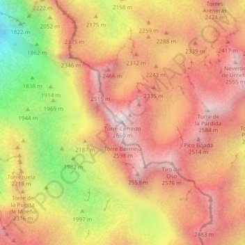
Name: Torre Cerredo topographic map, elevation, terrain.
Average elevation: 7,178 ft
Minimum elevation: 4,879 ft
Maximum elevation: 8,612 ft
Make a donation
Gear up for your next adventure:
As an Amazon Associate, this site earns from qualifying purchases at no extra cost to you.
Other topographic maps
Click on a map to view its topography, its elevation and its terrain.