Geolocate

Eschwege topographic map

Click on the map to display elevation.

About this map

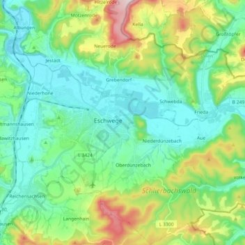
Name: Eschwege topographic map, elevation, terrain.

Location: Eschwege, Werra-Meißner-Kreis, Hesse, 37269, Germany (51.13017 9.95088 51.24140 10.12953)

Average elevation: 814 ft

Minimum elevation: 489 ft

Maximum elevation: 1,732 ft

Gear up for your next adventure:

🥩Freeze-Dried Meals - Nutritious and lightweight food for remote expeditions
🛡️Bear Spray Outdoor - Protection in bear country hikes
🧣Merino Neck Gaiters - Multi-functional headwear for wind and sun protection
🧺Microfiber Travel Towels - Compact and fast-drying towels for trail use
🚁Photography Drones - Capture stunning aerial views of landforms and topography

As an Amazon Associate, this site earns from qualifying purchases at no extra cost to you.