
Thank you for supporting this site ❤️
Make a donation
Make a donation
Gear up for your next adventure:
As an Amazon Associate, this site earns from qualifying purchases at no extra cost to you.
Porthmadog topographic map
Click on the map to display elevation.
Thank you for supporting this site ❤️
Make a donation
Make a donation
Gear up for your next adventure:
As an Amazon Associate, this site earns from qualifying purchases at no extra cost to you.
About this map
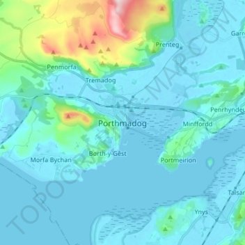
Name: Porthmadog topographic map, elevation, terrain.
Location: Porthmadog, Gwynedd, Wales, LL49 9LR, United Kingdom (52.88560 -4.16969 52.96560 -4.08969)
Average elevation: 141 ft
Minimum elevation: -10 ft
Maximum elevation: 1,168 ft
Thank you for supporting this site ❤️
Make a donation
Make a donation
Gear up for your next adventure:
As an Amazon Associate, this site earns from qualifying purchases at no extra cost to you.