
Make a donation
Gear up for your next adventure:
As an Amazon Associate, this site earns from qualifying purchases at no extra cost to you.
Berkeley Pit topographic map
Click on the map to display elevation.
Make a donation
Gear up for your next adventure:
As an Amazon Associate, this site earns from qualifying purchases at no extra cost to you.
Berkeley Pit
The mine is at 46°00′56″N 112°30′37″W / 46.01556°N 112.51028°W / 46.01556; -112.51028, at an altitude of 4,698 feet (1432 m) above mean sea level.
Make a donation
Gear up for your next adventure:
As an Amazon Associate, this site earns from qualifying purchases at no extra cost to you.
About this map
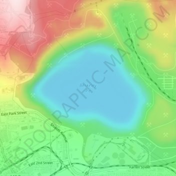
Name: Berkeley Pit topographic map, elevation, terrain.
Average elevation: 5,614 ft
Minimum elevation: 5,187 ft
Maximum elevation: 6,332 ft
Silver Bow County trails, hiking, mountain biking, running and outdoor activities
Make a donation
Gear up for your next adventure:
As an Amazon Associate, this site earns from qualifying purchases at no extra cost to you.
Other topographic maps
Click on a map to view its topography, its elevation and its terrain.
Little Granulated Mountain
United States > Montana > Silver Bow County > Butte
Average elevation: 8,389 ft