
Make a donation
Gear up for your next adventure:
As an Amazon Associate, this site earns from qualifying purchases at no extra cost to you.
Perumal Mala topographic map
Click on the map to display elevation.
Make a donation
Gear up for your next adventure:
As an Amazon Associate, this site earns from qualifying purchases at no extra cost to you.
About this map
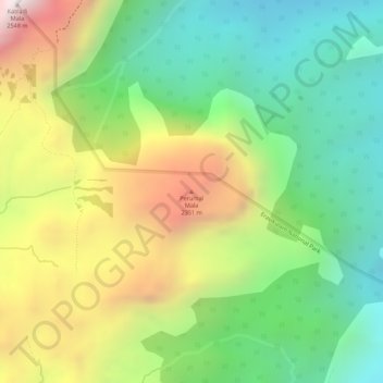
Name: Perumal Mala topographic map, elevation, terrain.
Location: Perumal Mala, Devikulam, Idukki, Kerala, India (10.24102 77.11039 10.24112 77.11049)
Average elevation: 6,637 ft
Minimum elevation: 5,377 ft
Maximum elevation: 8,356 ft
Make a donation
Gear up for your next adventure:
As an Amazon Associate, this site earns from qualifying purchases at no extra cost to you.
Other topographic maps
Click on a map to view its topography, its elevation and its terrain.
Anamudi Shola National Park
India > Kerala > Devikulam > Marayoor > Champakkad
Average elevation: 6,096 ft
Make a donation
Gear up for your next adventure:
As an Amazon Associate, this site earns from qualifying purchases at no extra cost to you.