
Make a donation
Gear up for your next adventure:
As an Amazon Associate, this site earns from qualifying purchases at no extra cost to you.
Comuna 9 - Buenos Aires topographic map
Click on the map to display elevation.
Make a donation
Gear up for your next adventure:
As an Amazon Associate, this site earns from qualifying purchases at no extra cost to you.
About this map
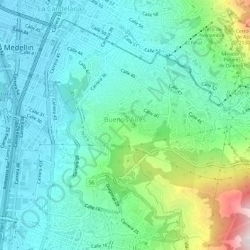
Name: Comuna 9 - Buenos Aires topographic map, elevation, terrain.
Average elevation: 5,456 ft
Minimum elevation: 4,790 ft
Maximum elevation: 7,753 ft
Make a donation
Gear up for your next adventure:
As an Amazon Associate, this site earns from qualifying purchases at no extra cost to you.
Other topographic maps
Click on a map to view its topography, its elevation and its terrain.
Make a donation
Gear up for your next adventure:
As an Amazon Associate, this site earns from qualifying purchases at no extra cost to you.
Parque del Barrio Alfonso Lopez
Colombia > Antioquia > Perímetro Urbano Medellín
Average elevation: 5,079 ft
Parque Biblioteca Presbítero José Luis Arroyave - San Javier
Colombia > Antioquia > Perímetro Urbano Medellín
Average elevation: 5,203 ft
Make a donation
Gear up for your next adventure:
As an Amazon Associate, this site earns from qualifying purchases at no extra cost to you.