
Make a donation
Gear up for your next adventure:
As an Amazon Associate, this site earns from qualifying purchases at no extra cost to you.
Fisching topographic map
Click on the map to display elevation.
Make a donation
Gear up for your next adventure:
As an Amazon Associate, this site earns from qualifying purchases at no extra cost to you.
About this map
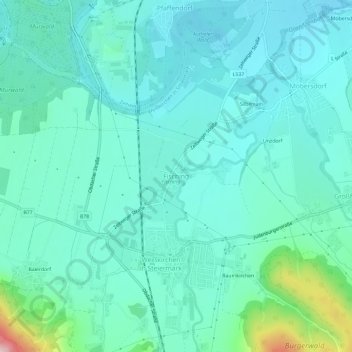
Name: Fisching topographic map, elevation, terrain.
Average elevation: 2,280 ft
Minimum elevation: 2,113 ft
Maximum elevation: 3,087 ft
Make a donation
Gear up for your next adventure:
As an Amazon Associate, this site earns from qualifying purchases at no extra cost to you.
Other topographic maps
Click on a map to view its topography, its elevation and its terrain.
Hohentauern
Oostenrijk > Stiermarken > Bezirk Murtal
Hohentauern is een klein dorp dat zich de laatste tijd steeds meer richt op sportactiviteiten. In de winter kan men skiën in het skigebied van ca 17 km pistes van verschillende klasses. Het dorp ligt op 1200 meter hoogte alwaar de skilift begint. De hoogte van het gebied gaat tot 1874 meter. De bergen in de…
Average elevation: 5,003 ft