
Make a donation
Gear up for your next adventure:
As an Amazon Associate, this site earns from qualifying purchases at no extra cost to you.
Strausberg topographic map
Click on the map to display elevation.
Make a donation
Gear up for your next adventure:
As an Amazon Associate, this site earns from qualifying purchases at no extra cost to you.
Strausberg
Zur Stadt gehört der Ortsteil Hohenstein mit den Wohnplätzen Gladowshöhe und Ruhlsdorf. Darüber hinaus existieren die folgenden 16 Wohnplätze: Alte Walkmühle, Fasanenpark, Friedrich-Schiller-Höhe, Gartenstadt, Hohensteiner Mühle, Jenseits des Sees, Neue Mühle, Postbruch, Provinzialsiedlung, Roter Hof, Spitzmühle, Steuerhaus, Torfhaus, Treuenhof und Wilhelmshof.
Make a donation
Gear up for your next adventure:
As an Amazon Associate, this site earns from qualifying purchases at no extra cost to you.
About this map
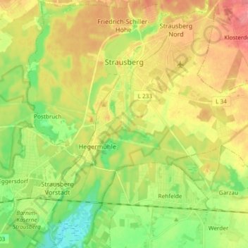
Name: Strausberg topographic map, elevation, terrain.
Location: Strausberg, Märkisch-Oderland, Brandenburg, Deutschland (52.51420 13.81318 52.60352 13.94035)
Average elevation: 226 ft
Minimum elevation: 115 ft
Maximum elevation: 348 ft
Make a donation
Gear up for your next adventure:
As an Amazon Associate, this site earns from qualifying purchases at no extra cost to you.
Other topographic maps
Click on a map to view its topography, its elevation and its terrain.
Straussee
Deutschland > Brandenburg > Märkisch-Oderland > Strausberg > Strausberg
Average elevation: 246 ft
Neue Mühle
Deutschland > Brandenburg > Märkisch-Oderland > Strausberg > Strausberg
Average elevation: 180 ft