Geolocate

Smyrna topographic map

Click on the map to display elevation.

About this map

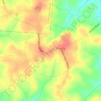
Name: Smyrna topographic map, elevation, terrain.

Location: Smyrna, York County, South Carolina, United States (35.03515 -81.41783 35.04890 -81.40104)

Average elevation: 692 ft

Minimum elevation: 574 ft

Maximum elevation: 778 ft

York County trails, hiking, mountain biking, running and outdoor activities

Other topographic maps

Click on a map to view its topography, its elevation and its terrain.

Catawba

United States > South Carolina > York County

Average elevation: 581 ft

Fort Mill

United States > South Carolina > York County > Fort Mill

Average elevation: 597 ft

Boyd Hill

United States > South Carolina > York County > Rock Hill

Average elevation: 630 ft

York

United States > South Carolina > York County > York > York

Average elevation: 643 ft

Beersheba

United States > South Carolina > York County > Beersheba

Average elevation: 653 ft

Mexico

United States > South Carolina > York County > Rock Hill

Average elevation: 627 ft

Old Farm

United States > South Carolina > York County > Rock Hill

Average elevation: 636 ft

Gear up for your next adventure:

👖Convertible Hiking Pants - Versatile zip-off pants for changing altitudes and temperatures
🥄Camping Utensil Set - Lightweight utensils for outdoor meals
🦺Reflective Outdoor Gear - Safety gear for low‑light conditions
🧥Waterproof Jacket for Hiking - Breathable and rugged rain jacket for outdoor excursions
🔥Plasma Lighters - Windproof lighters that work in any weather condition

As an Amazon Associate, this site earns from qualifying purchases at no extra cost to you.