Geolocate

Nixon topographic map

Click on the map to display elevation.

About this map

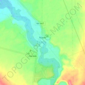
Name: Nixon topographic map, elevation, terrain.

Location: Nixon, Washoe County, Nevada, 89424, United States (39.80731 -119.39177 39.85053 -119.32613)

Average elevation: 3,967 ft

Minimum elevation: 3,862 ft

Maximum elevation: 4,147 ft

Other topographic maps

Click on a map to view its topography, its elevation and its terrain.

Mount Rose

United States > Nevada > Washoe County

Average elevation: 9,577 ft

State Line Peak

United States > Nevada > Washoe County

Average elevation: 6,952 ft

Verdi

United States > Nevada > Washoe County

Average elevation: 5,062 ft

Gerlach

United States > Nevada > Washoe County

According to the United States Census Bureau, the Gerlach CDP has a total area of 3.1 square miles (8.0 km2), all land. Its elevation is 3,944 ft (1,202 m). Gerlach is approximately 100 miles (160 km) north of Reno, Nevada.

Average elevation: 3,963 ft

Red Rock

United States > Nevada > Washoe County

Average elevation: 4,803 ft

Palomino Valley

United States > Nevada > Washoe County

Average elevation: 4,370 ft

Golden Valley Park

United States > Nevada > Washoe County > Reno

Average elevation: 5,171 ft

Lemmon Valley

United States > Nevada > Washoe County

Average elevation: 5,049 ft

Tohakum Peak

United States > Nevada > Washoe County

Average elevation: 6,883 ft

Highland Reservoir

United States > Nevada > Washoe County > Reno

Average elevation: 4,665 ft

Mount Rose

United States > Nevada > Washoe County

Average elevation: 9,577 ft

Red Rock

United States > Nevada > Washoe County

Average elevation: 4,803 ft

Mount Rose

United States > Nevada > Washoe County

Average elevation: 9,577 ft

Lemmon Valley

United States > Nevada > Washoe County

Average elevation: 5,049 ft

Verdi

United States > Nevada > Washoe County

Average elevation: 5,062 ft

Cold Springs

United States > Nevada > Washoe County

Average elevation: 5,161 ft

Sand Pass

United States > Nevada > Washoe County

Average elevation: 4,117 ft

Incline Village

United States > Nevada > Washoe County

Average elevation: 7,136 ft

Gear up for your next adventure:

🔌Solar Panel Charger - Charge gear sustainably outdoors
👟Trail Running Shoes - Lightweight shoes for trail runners
🔭Telescopic Hiking Pole - Adjustable pole for hiking stability
🎒Gear Packing Cubes - Organize your backpack efficiently
🔪Outdoor Multitools - Essential survival tools for gear repair and field use

As an Amazon Associate, this site earns from qualifying purchases at no extra cost to you.