
Make a donation
Gear up for your next adventure:
As an Amazon Associate, this site earns from qualifying purchases at no extra cost to you.
Peru topographic map
Click on the map to display elevation.
Make a donation
Gear up for your next adventure:
As an Amazon Associate, this site earns from qualifying purchases at no extra cost to you.
Peru
Peru is located in northeastern Bennington County, bordered by Rutland County to the north. The crest of the Green Mountains runs from north to the south through the western half of the town, traversed by the Long Trail/Appalachian Trail. 3,300-foot-high (1,000 m) Bromley Mountain and its ski area are in the southern part of the town, and 3,392-foot (1,034 m) Styles Peak and 3,428-foot (1,045 m) Peru Peak are to the north. The village or town center of Peru is in the southeastern part of town, at elevation 1,706 feet (520 m). Vermont Route 11 crosses the southeastern part of the town, through the town center and past Bromley Mountain Ski Area.
Make a donation
Gear up for your next adventure:
As an Amazon Associate, this site earns from qualifying purchases at no extra cost to you.
About this map
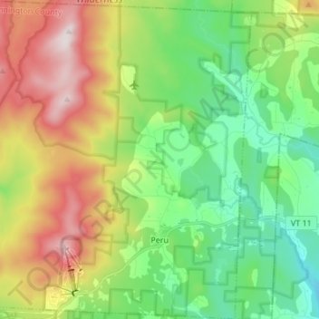
Name: Peru topographic map, elevation, terrain.
Location: Peru, Bennington County, Vermont, 05152, United States (43.20542 -72.97959 43.30416 -72.85991)
Average elevation: 1,952 ft
Minimum elevation: 1,119 ft
Maximum elevation: 3,399 ft
Bennington County trails, hiking, mountain biking, running and outdoor activities
Make a donation
Gear up for your next adventure:
As an Amazon Associate, this site earns from qualifying purchases at no extra cost to you.
Other topographic maps
Click on a map to view its topography, its elevation and its terrain.
Make a donation
Gear up for your next adventure:
As an Amazon Associate, this site earns from qualifying purchases at no extra cost to you.
Make a donation
Gear up for your next adventure:
As an Amazon Associate, this site earns from qualifying purchases at no extra cost to you.