Geolocate

Gloria topographic map

Click on the map to display elevation.

About this map

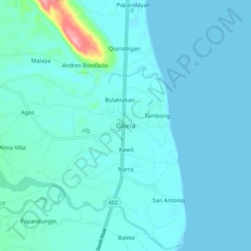
Name: Gloria topographic map, elevation, terrain.

Location: Gloria, Oriental Mindoro, Mimaropa, 5213, Philippines (12.92885 121.43853 13.00885 121.51853)

Average elevation: 39 ft

Minimum elevation: 0 ft

Maximum elevation: 433 ft

Other topographic maps

Click on a map to view its topography, its elevation and its terrain.

Bongabong River

Philippines > Oriental Mindoro

Average elevation: 1,972 ft

Inclanay Dam

Philippines > Oriental Mindoro > Inclanay > Pansulan

Average elevation: 95 ft

Bansud River

Philippines > Oriental Mindoro > Conrazon

Average elevation: 1,132 ft

Naujan Lake

Philippines > Oriental Mindoro > Malabo

Average elevation: 151 ft

Masipit

Philippines > Oriental Mindoro > Calapan

Average elevation: 13 ft

Tawiran

Philippines > Oriental Mindoro > Calapan

Average elevation: 20 ft

Lalud

Philippines > Oriental Mindoro > Calapan > Guinobatan

Average elevation: 26 ft

Gear up for your next adventure:

🦶Hiking Gaiters - Keep debris and water out of your boots
📶Vehicle Signal Boosters - Improve reception in rural areas while driving to trailheads
📦Dry Bags Set - Waterproof storage for electronics and clothes
🗃️Trail First Aid Kit - Essential kit for outdoor injuries and emergencies
📷Action Camera - Capture your outdoor adventures in HD

As an Amazon Associate, this site earns from qualifying purchases at no extra cost to you.