Geolocate

Lecompton topographic map

Click on the map to display elevation.

About this map

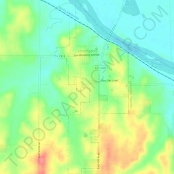
Name: Lecompton topographic map, elevation, terrain.

Location: Lecompton, Douglas County, Kansas, United States (39.01507 -95.40503 39.05736 -95.38194)

Average elevation: 922 ft

Minimum elevation: 820 ft

Maximum elevation: 1,086 ft

Douglas County trails, hiking, mountain biking, running and outdoor activities

Other topographic maps

Click on a map to view its topography, its elevation and its terrain.

Potter Lake

United States > Kansas > Douglas County > Lawrence

Average elevation: 932 ft

Gear up for your next adventure:

🪶Multi‑Purpose Knife - Useful blade for camp and trail
📶Vehicle Signal Boosters - Improve reception in rural areas while driving to trailheads
🧥Men's Rain Shells - Premium waterproof and breathable jackets for mountain weather
🔊Portable Camp Speaker - Music and alerts at camp
🪶LED Camping Lantern - Bright lantern for camp lighting

As an Amazon Associate, this site earns from qualifying purchases at no extra cost to you.