
Make a donation
Gear up for your next adventure:
As an Amazon Associate, this site earns from qualifying purchases at no extra cost to you.
Travnik topographic map
Click on the map to display elevation.
Make a donation
Gear up for your next adventure:
As an Amazon Associate, this site earns from qualifying purchases at no extra cost to you.
About this map
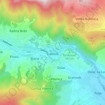
Name: Travnik topographic map, elevation, terrain.
Average elevation: 2,434 ft
Minimum elevation: 1,529 ft
Maximum elevation: 4,354 ft
Make a donation
Gear up for your next adventure:
As an Amazon Associate, this site earns from qualifying purchases at no extra cost to you.
Other topographic maps
Click on a map to view its topography, its elevation and its terrain.
Sarajevo
Bosnia and Herzegovina > Federation of Bosnia and Herzegovina > Sarajevo
Average elevation: 3,117 ft
City of Sarajevo
Bosnia and Herzegovina > Federation of Bosnia and Herzegovina
Average elevation: 2,657 ft
Mostar
Bosnia and Herzegovina > Federation of Bosnia and Herzegovina > City of Mostar
Average elevation: 1,975 ft
Make a donation
Gear up for your next adventure:
As an Amazon Associate, this site earns from qualifying purchases at no extra cost to you.
Zenica
Bosnia and Herzegovina > Federation of Bosnia and Herzegovina > City of Zenica
The city is geographically located in the heart of Bosnia. The settled area is 43.01 km2 (16.61 sq mi) and of the city proper covers 558.5 km2 (215.6 sq mi). Elevation is 310–350 m (1,017–1,148 ft). The rivers Bosna, Lašva, Babina, and Kočeva flow through the settlement. A moderate continental climate…
Average elevation: 2,395 ft
Tuzla
Bosnia and Herzegovina > Federation of Bosnia and Herzegovina > City of Tuzla
Average elevation: 1,145 ft
Make a donation
Gear up for your next adventure:
As an Amazon Associate, this site earns from qualifying purchases at no extra cost to you.
Gračanica
Bosnia and Herzegovina > Federation of Bosnia and Herzegovina > Town of Gračanica > Gračanica
Average elevation: 876 ft
Jablanica
Bosnia and Herzegovina > Federation of Bosnia and Herzegovina
The mean elevation of Jablanica is 202 metres (663 ft) above sea level. Some 69% of the municipalities 301 km2 (116 sq mi) of area is forested. The Jablanica lake is an important geographical as well as economic presence in Jablanica.
Average elevation: 1,535 ft
Čapljina
Bosnia and Herzegovina > Federation of Bosnia and Herzegovina > City of Čapljina
Average elevation: 322 ft
Make a donation
Gear up for your next adventure:
As an Amazon Associate, this site earns from qualifying purchases at no extra cost to you.
Žitomislići
Bosnia and Herzegovina > Federation of Bosnia and Herzegovina > City of Mostar
Average elevation: 630 ft
Make a donation
Gear up for your next adventure:
As an Amazon Associate, this site earns from qualifying purchases at no extra cost to you.
Široki Brijeg
Bosnia and Herzegovina > Federation of Bosnia and Herzegovina > City of Široki Brijeg
Neogenic layers are built of marl, sandy clay, sandstone and conglomerates, and can be found in the vicinity of Grabovo Drage and Mostarsko Blato. Quaternary banks of pebbles, sand and water karst saturated found on almost all rocky fields and drifts along the river beds. Between the lower mountain Vardi,…
Average elevation: 1,329 ft
Make a donation
Gear up for your next adventure:
As an Amazon Associate, this site earns from qualifying purchases at no extra cost to you.
Lukavac
Bosnia and Herzegovina > Federation of Bosnia and Herzegovina > Town of Lukavac
Average elevation: 728 ft
Srebrenik
Bosnia and Herzegovina > Federation of Bosnia and Herzegovina > Town of Srebrenik > Srebrenik
Average elevation: 948 ft
Bosnian-Podrinje Canton Goražde
Bosnia and Herzegovina > Federation of Bosnia and Herzegovina
Average elevation: 2,877 ft
Dubrovnik
Bosnia and Herzegovina > Federation of Bosnia and Herzegovina > Kamenica
Average elevation: 2,772 ft
Make a donation
Gear up for your next adventure:
As an Amazon Associate, this site earns from qualifying purchases at no extra cost to you.
Pribava
Bosnia and Herzegovina > Federation of Bosnia and Herzegovina > Town of Gračanica > Pribava
Average elevation: 682 ft
Novi Travnik
Bosnia and Herzegovina > Federation of Bosnia and Herzegovina > Novi Travnik
Average elevation: 2,264 ft
Lom
Bosnia and Herzegovina > Federation of Bosnia and Herzegovina > Stari Teočak
Average elevation: 1,644 ft
Make a donation
Gear up for your next adventure:
As an Amazon Associate, this site earns from qualifying purchases at no extra cost to you.
West Herzegovina Canton
Bosnia and Herzegovina > Federation of Bosnia and Herzegovina
This region, before the war, was one of the poorest regions in BiH. Today it is one of the richest. Despite the canton's small size in area, its agricultural sector is important. In the canton, 30,000 ha (120 sq miles) is used for agriculture; 84,000 ha (320 sq miles) is forest. Around 6,000 ha of arable land…
Average elevation: 1,946 ft
Centar Municipality
Bosnia and Herzegovina > Federation of Bosnia and Herzegovina > City of Sarajevo
Average elevation: 2,812 ft