
Vinac topographic map
Click on the map to display elevation.
About this map
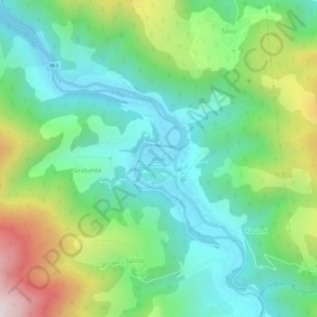
Name: Vinac topographic map, elevation, terrain.
Average elevation: 2,178 ft
Minimum elevation: 1,220 ft
Maximum elevation: 4,347 ft
Other topographic maps
Click on a map to view its topography, its elevation and its terrain.
City of Sarajevo
Bosnia and Herzegovina > Federation of Bosnia and Herzegovina
Average elevation: 2,657 ft
Rama
Bosnia and Herzegovina > Federation of Bosnia and Herzegovina > Gračanica
Average elevation: 2,385 ft
Boračko jezero
Bosnia and Herzegovina > Federation of Bosnia and Herzegovina > Town of Konjic > Jezero
It lies at the northeastern foot of the mountain Prenj, at an altitude 397 m. From the west it is surrounded by steep forested mountain slopes of Crna Gora (Black Mountain, 1343 m), and from the east by Tranjine (1055 m). The lake basin was created in the Boračka draga, during the expansive process of glacial…
Average elevation: 2,185 ft
Velež
Bosnia and Herzegovina > Federation of Bosnia and Herzegovina > Town of Zavidovići
Average elevation: 1,759 ft
Bosnian-Podrinje Canton Goražde
Bosnia and Herzegovina > Federation of Bosnia and Herzegovina
Average elevation: 2,877 ft
Centar Municipality
Bosnia and Herzegovina > Federation of Bosnia and Herzegovina > City of Sarajevo
Average elevation: 2,812 ft