
Valldemossa topographic map
Click on the map to display elevation.
About this map
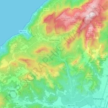
Name: Valldemossa topographic map, elevation, terrain.
Location: Valldemossa, Serra de Tramuntana, Balearic Islands, 07170, Spain (39.65481 2.55579 39.74367 2.66221)
Average elevation: 1,181 ft
Minimum elevation: 0 ft
Maximum elevation: 3,478 ft
Other topographic maps
Click on a map to view its topography, its elevation and its terrain.
sa Calobra
Spain > Balearic Islands > Serra de Tramuntana > Escorca
The port village is a popular destination for coach trips and road cyclists. It is accessed by a single winding road, designed by Italian-Spanish engineer Antonio Parietti and opened in 1933, which features many hairpin bends and a 270° spiral bridge called the tie knot. The climb is officially called the…
Average elevation: 840 ft