Geolocate

Wasola topographic map

Click on the map to display elevation.

About this map

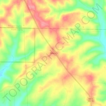
Name: Wasola topographic map, elevation, terrain.

Location: Wasola, Ozark County, Missouri, United States (36.77367 -92.59572 36.81367 -92.55572)

Average elevation: 1,184 ft

Minimum elevation: 1,007 ft

Maximum elevation: 1,332 ft

Ozark County trails, hiking, mountain biking, running and outdoor activities

Other topographic maps

Click on a map to view its topography, its elevation and its terrain.

Theodosia

United States > Missouri > Ozark County

Average elevation: 817 ft

Bakersfield

United States > Missouri > Ozark County

Average elevation: 801 ft

Gainesville

United States > Missouri > Ozark County

Average elevation: 919 ft

Gear up for your next adventure:

🏔️Mountain Trail Maps - High‑detail maps for popular peaks
🥄Camping Utensil Set - Lightweight utensils for outdoor meals
🦟Ultrasonic Repellers - Create a bug-free zone at your camp or rest stop
🩳Quick‑Dry Hiking Shorts - Comfortable and quick‑dry shorts for summer hiking
🪓Survival Multi‑Tool - Versatile tool for camp and trail tasks

As an Amazon Associate, this site earns from qualifying purchases at no extra cost to you.