
Make a donation
Gear up for your next adventure:
As an Amazon Associate, this site earns from qualifying purchases at no extra cost to you.
Kriel topographic map
Click on the map to display elevation.
Make a donation
Gear up for your next adventure:
As an Amazon Associate, this site earns from qualifying purchases at no extra cost to you.
Kriel
Hot summers and very cold winters. Rainfall approximately 660 mm per annum. Altitude 1598 m above sea level.
Make a donation
Gear up for your next adventure:
As an Amazon Associate, this site earns from qualifying purchases at no extra cost to you.
About this map
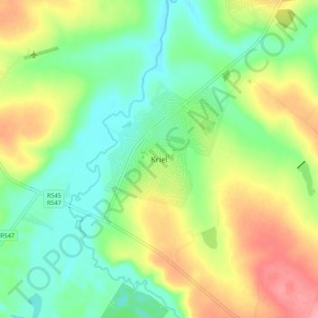
Name: Kriel topographic map, elevation, terrain.
Average elevation: 5,148 ft
Minimum elevation: 5,020 ft
Maximum elevation: 5,344 ft
Make a donation
Gear up for your next adventure:
As an Amazon Associate, this site earns from qualifying purchases at no extra cost to you.
Other topographic maps
Click on a map to view its topography, its elevation and its terrain.
Rietfontein Dam
South Africa > Mpumalanga > Nkangala > Emalahleni Local Municipality
Average elevation: 5,141 ft