Geolocate

Pansol topographic map

Click on the map to display elevation.

About this map

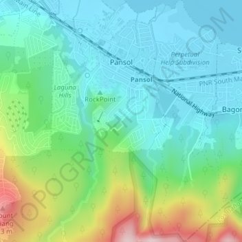
Name: Pansol topographic map, elevation, terrain.

Location: Pansol, Calamba, Laguna, Calabarzon, 4027, Philippines (14.15728 121.17202 14.18746 121.19438)

Average elevation: 318 ft

Minimum elevation: 3 ft

Maximum elevation: 1,184 ft

Other topographic maps

Click on a map to view its topography, its elevation and its terrain.

Bucal

Philippines > Laguna > Calamba

Average elevation: 72 ft

88 Spa & Resort

Philippines > Laguna > Calamba

Average elevation: 272 ft

ASN Ph2 Park

Philippines > Laguna > Calamba

Average elevation: 436 ft

Bucal Reservoir

Philippines > Laguna > Calamba

Average elevation: 138 ft

Calamba Town Plaza

Philippines > Laguna > Calamba

Average elevation: 36 ft

Gear up for your next adventure:

🔌Solar Panel Charger - Charge gear sustainably outdoors
🥘Titanium Cookware - Durable, featherlight pots and pans for backpacking
🌧️Backpack Rain Cover - Keep gear dry in wet weather
🔌USB Car Charger - Car charger for on‑the‑go power needs
🧭Pro Hiking Compasses - High-accuracy liquid-filled compasses for topographic orientation

As an Amazon Associate, this site earns from qualifying purchases at no extra cost to you.