
Make a donation
Gear up for your next adventure:
As an Amazon Associate, this site earns from qualifying purchases at no extra cost to you.
Pahalgam topographic map
Click on the map to display elevation.
Make a donation
Gear up for your next adventure:
As an Amazon Associate, this site earns from qualifying purchases at no extra cost to you.
Pahalgam
Pahalgam (Urdu pronunciation: [pɛɦɛlɡɑːm]) or Pahalgom (Kashmiri pronunciation: [pəhəlʲɡoːm]) is a town in Anantnag district of the Indian union territory of Jammu and Kashmir. It is located on the banks of Lidder River at an altitude of 2,200 m (7,200 ft) in the Vale of Kashmir. Pahalgam is the headquarters of the Pahalgam tehsil, one of the eleven tehsils in Anantnag district.
Make a donation
Gear up for your next adventure:
As an Amazon Associate, this site earns from qualifying purchases at no extra cost to you.
About this map
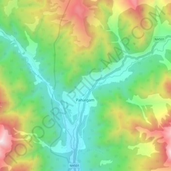
Name: Pahalgam topographic map, elevation, terrain.
Location: Pahalgam, Anantnag, Jammu and Kashmir, 192126, India (33.99220 75.28265 34.07220 75.36265)
Average elevation: 8,858 ft
Minimum elevation: 6,831 ft
Maximum elevation: 12,825 ft
Make a donation
Gear up for your next adventure:
As an Amazon Associate, this site earns from qualifying purchases at no extra cost to you.