
Make a donation
Gear up for your next adventure:
As an Amazon Associate, this site earns from qualifying purchases at no extra cost to you.
Clairvaux topographic map
Click on the map to display elevation.
Make a donation
Gear up for your next adventure:
As an Amazon Associate, this site earns from qualifying purchases at no extra cost to you.
About this map
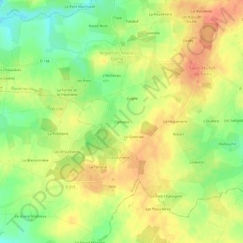
Name: Clairvaux topographic map, elevation, terrain.
Average elevation: 220 ft
Minimum elevation: 131 ft
Maximum elevation: 285 ft
Make a donation
Gear up for your next adventure:
As an Amazon Associate, this site earns from qualifying purchases at no extra cost to you.
Other topographic maps
Click on a map to view its topography, its elevation and its terrain.
Argenton-Notre-Dame
France > Pays de la Loire > Mayenne > Bierné-les-Villages
Le territoire d'Argenton recouvre une superficie de 677 hectares. C'est un terrain plat, légèrement incliné de l'est à l'ouest, où l'altitude varie de 82 à 33 m. Le Béron le limite au nord, sur une longueur 5 à 6 km.
Average elevation: 210 ft
Saint-Michel-de-Feins
France > Pays de la Loire > Mayenne > Bierné-les-Villages
Average elevation: 226 ft
Saint-Laurent-des-Mortiers
France > Pays de la Loire > Mayenne > Bierné-les-Villages
Average elevation: 210 ft