
Make a donation
Gear up for your next adventure:
As an Amazon Associate, this site earns from qualifying purchases at no extra cost to you.
Porco topographic map
Click on the map to display elevation.
Make a donation
Gear up for your next adventure:
As an Amazon Associate, this site earns from qualifying purchases at no extra cost to you.
About this map
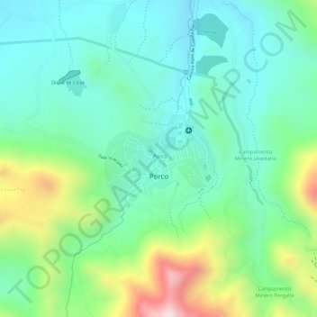
Name: Porco topographic map, elevation, terrain.
Location: Porco, Municipio Porco, Antonio Quijarro, Potosí, Bolivia (-19.80159 -65.99276 -19.79403 -65.98258)
Average elevation: 13,625 ft
Minimum elevation: 13,199 ft
Maximum elevation: 14,583 ft
Make a donation
Gear up for your next adventure:
As an Amazon Associate, this site earns from qualifying purchases at no extra cost to you.
Other topographic maps
Click on a map to view its topography, its elevation and its terrain.
Aguas Termales
Bolivia > Potosí > Antonio Quijarro > Municipio Porco > Visigza
Average elevation: 12,776 ft
Make a donation
Gear up for your next adventure:
As an Amazon Associate, this site earns from qualifying purchases at no extra cost to you.