
Thank you for supporting this site ❤️
Make a donation
Make a donation
Gear up for your next adventure:
As an Amazon Associate, this site earns from qualifying purchases at no extra cost to you.
Sette topographic map
Click on the map to display elevation.
Thank you for supporting this site ❤️
Make a donation
Make a donation
Gear up for your next adventure:
As an Amazon Associate, this site earns from qualifying purchases at no extra cost to you.
About this map
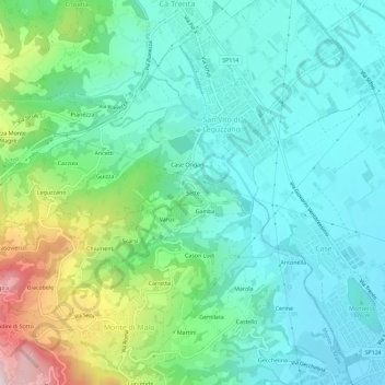
Name: Sette topographic map, elevation, terrain.
Location: Sette, San Vito di Leguzzano, Vicenza, Veneto, 36034, Italy (45.65441 11.35207 45.69441 11.39207)
Average elevation: 768 ft
Minimum elevation: 371 ft
Maximum elevation: 1,978 ft
Thank you for supporting this site ❤️
Make a donation
Make a donation
Gear up for your next adventure:
As an Amazon Associate, this site earns from qualifying purchases at no extra cost to you.