
Cotalo topographic map
Interactive map
Click on the map to display elevation.
About this map
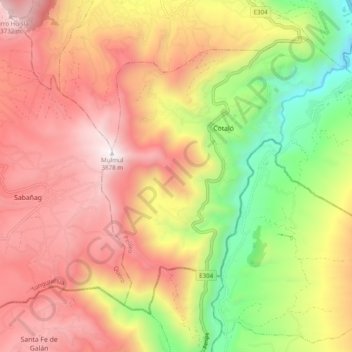
Name: Cotalo topographic map, elevation, terrain.
Location: Cotalo, Pelileo, Tungurahua, Ecuador (-1.48243 -78.54623 -1.40601 -78.44861)
Average elevation: 9,747 ft
Minimum elevation: 6,260 ft
Maximum elevation: 12,671 ft
Other topographic maps
Click on a map to view its topography, its elevation and its terrain.
Salasaca
Ecuador > Tungurahua > Pelileo
Salasaca, Pelileo, Tungurahua, Ecuador
Average elevation: 8,894 ft
Garcia Moreno (Chumaqui)
Ecuador > Tungurahua > Pelileo
Garcia Moreno (Chumaqui), Pelileo, Tungurahua, Ecuador
Average elevation: 8,494 ft