
Garcia Moreno (Chumaqui) topographic map
Interactive map
Click on the map to display elevation.
About this map
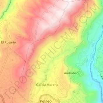
Name: Garcia Moreno (Chumaqui) topographic map, elevation, terrain.
Location: Garcia Moreno (Chumaqui), Pelileo, Tungurahua, Ecuador (-1.33062 -78.56233 -1.27013 -78.52074)
Average elevation: 8,494 ft
Minimum elevation: 6,614 ft
Maximum elevation: 10,098 ft
Other topographic maps
Click on a map to view its topography, its elevation and its terrain.
Salasaca
Ecuador > Tungurahua > Pelileo
Salasaca, Pelileo, Tungurahua, Ecuador
Average elevation: 8,894 ft