Geolocate

Crowders topographic map

Click on the map to display elevation.

About this map
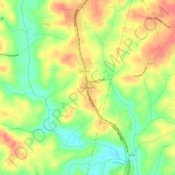
Name: Crowders topographic map, elevation, terrain.

Location: Crowders, Gaston County, North Carolina, 29703, United States (35.16625 -81.22647 35.20625 -81.18647)

Average elevation: 712 ft

Minimum elevation: 607 ft

Maximum elevation: 804 ft

Gaston County trails, hiking, mountain biking, running and outdoor activities

Other topographic maps

Click on a map to view its topography, its elevation and its terrain.
Ranlo

United States > North Carolina > Gaston County

Average elevation: 751 ft

McAdenville

United States > North Carolina > Gaston County

Average elevation: 686 ft

Lowell

United States > North Carolina > Gaston County

Average elevation: 719 ft

Dellview

United States > North Carolina > Gaston County

Average elevation: 932 ft

Gear up for your next adventure:

⌚GPS Sports Watch - GPS watch for running, hiking and training
🪶Thermal Camp Blanket - Extra warmth for cold nights
🚪Portable Camp Chair - Foldable chair for comfort at camp
🕶️GPS Smartphone Mount - Secure mount for phone navigation
📖Nature Tracking Books - Learn to track wildlife and terrain

As an Amazon Associate, this site earns from qualifying purchases at no extra cost to you.