Make a donation
Gear up for your next adventure:
As an Amazon Associate, this site earns from qualifying purchases at no extra cost to you.
Lowell topographic map
Click on the map to display elevation.
Make a donation
Gear up for your next adventure:
As an Amazon Associate, this site earns from qualifying purchases at no extra cost to you.
About this map
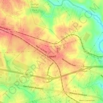
Name: Lowell topographic map, elevation, terrain.
Location: Lowell, Gaston County, North Carolina, 28098, United States (35.25166 -81.12189 35.28746 -81.08417)
Average elevation: 719 ft
Minimum elevation: 584 ft
Maximum elevation: 807 ft
Gaston County trails, hiking, mountain biking, running and outdoor activities
Make a donation
Gear up for your next adventure:
As an Amazon Associate, this site earns from qualifying purchases at no extra cost to you.
Other topographic maps
Click on a map to view its topography, its elevation and its terrain.
Make a donation
Gear up for your next adventure:
As an Amazon Associate, this site earns from qualifying purchases at no extra cost to you.
Make a donation
Gear up for your next adventure:
As an Amazon Associate, this site earns from qualifying purchases at no extra cost to you.
Carolina Industrial Park
United States > North Carolina > Gaston County > Cherryville
Average elevation: 909 ft
Gastonia
United States > North Carolina > Gaston County > Gastonia > Gastonia
Average elevation: 768 ft
Make a donation
Gear up for your next adventure:
As an Amazon Associate, this site earns from qualifying purchases at no extra cost to you.
Make a donation
Gear up for your next adventure:
As an Amazon Associate, this site earns from qualifying purchases at no extra cost to you.
