Geolocate

Le Morne-Rouge topographic map

Click on the map to display elevation.

About this map
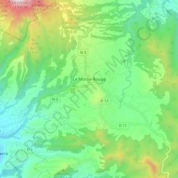
Name: Le Morne-Rouge topographic map, elevation, terrain.

Location: Le Morne-Rouge, Saint-Pierre, Martinique, 97260, France (14.73101 -61.15851 14.80827 -61.08483)

Average elevation: 1,352 ft

Minimum elevation: 49 ft

Maximum elevation: 4,393 ft

Other topographic maps

Click on a map to view its topography, its elevation and its terrain.

Belle Étoile

France > Martinique > Sainte-Marie

Average elevation: 141 ft

Canton Suisse

France > Martinique > Le Morne-Vert

Average elevation: 1,106 ft

Baie de Fort-de-France

France > Martinique

Average elevation: 0 ft

Le Diaka

France > Martinique > Le Marin

Average elevation: 125 ft

Gear up for your next adventure:

🏥Hiking First Aid Kits - Comprehensive medical kits for remote trail injuries
🩹Survival Bandages - High‑quality bandages for emergencies
🧥Men's Rain Shells - Premium waterproof and breathable jackets for mountain weather
🪑Portable Camp Table - Compact table for campsite meals
🪶Camp Gear Gift Set - Perfect gift bundle for outdoor fans

As an Amazon Associate, this site earns from qualifying purchases at no extra cost to you.