Geolocate

Boluo County topographic map

Click on the map to display elevation.

About this map

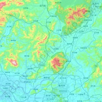
Name: Boluo County topographic map, elevation, terrain.

Location: Boluo County, Huizhou, Guangdong Province, China (23.05034 113.83922 23.70952 114.69448)

Average elevation: 440 ft

Minimum elevation: -10 ft

Maximum elevation: 4,006 ft

Other topographic maps

Click on a map to view its topography, its elevation and its terrain.

Baitang

China > Guangdong Province > Huizhou

Average elevation: 243 ft

Dipa

China > Guangdong Province > Huizhou

Average elevation: 1,037 ft

Gear up for your next adventure:

🛡️Bear Spray Outdoor - Protection in bear country hikes
📱Solar Portable Charger - Solar power bank for charging devices off‑grid
🔭Telescopic Hiking Pole - Adjustable pole for hiking stability
GPS Sports Watch - GPS watch for running, hiking and training
🔦LED Headlamp - Bright and durable LED headlamp for night navigation

As an Amazon Associate, this site earns from qualifying purchases at no extra cost to you.