
El Aserradero topographic map
Interactive map
Click on the map to display elevation.
About this map
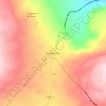
Name: El Aserradero topographic map, elevation, terrain.
Location: El Aserradero, Cuautepec de Hinojosa, Hidalgo, México (19.93361 -98.34556 19.97361 -98.30556)
Average elevation: 8,609 ft
Minimum elevation: 7,920 ft
Maximum elevation: 8,996 ft
Other topographic maps
Click on a map to view its topography, its elevation and its terrain.
Benito Juárez
México > Hidalgo > Cuautepec de Hinojosa > Benito Juárez
Benito Juárez, Cuautepec de Hinojosa, Hidalgo, México
Average elevation: 7,352 ft