Geolocate

Seville topographic map

Click on the map to display elevation.

About this map

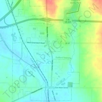
Name: Seville topographic map, elevation, terrain.

Location: Seville, Medina County, Ohio, United States (41.00518 -81.88744 41.03993 -81.84950)

Average elevation: 1,040 ft

Minimum elevation: 974 ft

Maximum elevation: 1,191 ft

Medina County trails, hiking, mountain biking, running and outdoor activities

Other topographic maps

Click on a map to view its topography, its elevation and its terrain.

Abbeyville

United States > Ohio > Medina County

Average elevation: 912 ft

Hinckley

United States > Ohio > Medina County

Average elevation: 1,083 ft

Litchfield

United States > Ohio > Medina County

Average elevation: 1,004 ft

Valley City

United States > Ohio > Medina County

Average elevation: 860 ft

Valley City

United States > Ohio > Medina County

Average elevation: 860 ft

Valley City

United States > Ohio > Medina County

Average elevation: 860 ft

Wadsworth

United States > Ohio > Medina County > Wadsworth

Average elevation: 1,129 ft

Gear up for your next adventure:

🧭GPS Watch Accessories - Bands and chargers for GPS watches
🦟Ultrasonic Repellers - Create a bug-free zone at your camp or rest stop
🪶Wildlife Field Guides - Learn animal tracking and species ID
🚗GPS Dash Cams - Record your scenic drives through mountain passes and canyons
🧥Men's Rain Shells - Premium waterproof and breathable jackets for mountain weather

As an Amazon Associate, this site earns from qualifying purchases at no extra cost to you.