Geolocate

Whitecraig topographic map

Click on the map to display elevation.

About this map

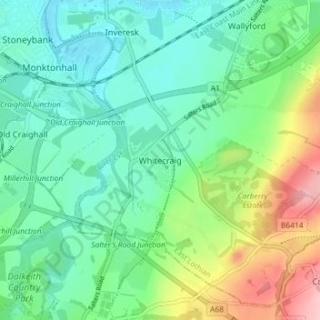
Name: Whitecraig topographic map, elevation, terrain.

Location: Whitecraig, East Lothian, Scotland, EH21 8NP, United Kingdom (55.89954 -3.05578 55.93954 -3.01578)

Average elevation: 171 ft

Minimum elevation: 23 ft

Maximum elevation: 535 ft

Other topographic maps

Click on a map to view its topography, its elevation and its terrain.

Firth of Forth

United Kingdom > Scotland > East Lothian

Average elevation: 285 ft

Lammermuirs

United Kingdom > Scotland > East Lothian

Average elevation: 873 ft

Bass Rock

United Kingdom > Scotland > East Lothian

Average elevation: 0 ft

River Esk

United Kingdom > Scotland > East Lothian > Musselburgh

Average elevation: 23 ft

Coldale Wood

United Kingdom > Scotland > East Lothian

Average elevation: 213 ft

Gear up for your next adventure:

🧭GPS Watch Accessories - Bands and chargers for GPS watches
❄️Traction Cleats - Prevent slips on icy trails during winter hikes
🗺️Topographic Maps - Detailed topo maps for hiking, exploring and outdoor navigation
🏔️Mountain Trail Maps - High‑detail maps for popular peaks
🪶Compact Camp Shovel - Folding shovel for campsite tasks

As an Amazon Associate, this site earns from qualifying purchases at no extra cost to you.