Geolocate

Cabugao topographic map

Click on the map to display elevation.

About this map

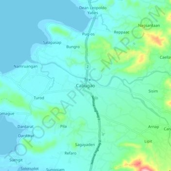
Name: Cabugao topographic map, elevation, terrain.

Location: Cabugao, Ilocos Sur, Ilocos Region, 2732, Philippines (17.75448 120.41495 17.83448 120.49495)

Average elevation: 82 ft

Minimum elevation: 0 ft

Maximum elevation: 538 ft

Other topographic maps

Click on a map to view its topography, its elevation and its terrain.

Bessang Pass

Philippines > Ilocos Sur

Average elevation: 4,518 ft

Gear up for your next adventure:

🌄Hiking Binoculars - Compact binoculars for scenic views and trail spotting
🧴Hand Sanitizer - Keep hands clean while hiking
🍳Camping Cook Set - Complete cookware for outdoor meals
🪶Wildlife Field Guides - Learn animal tracking and species ID
❄️Traction Cleats - Prevent slips on icy trails during winter hikes

As an Amazon Associate, this site earns from qualifying purchases at no extra cost to you.