Geolocate

Kiedrich topographic map

Click on the map to display elevation.

About this map

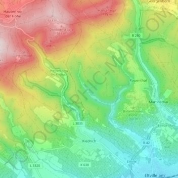
Name: Kiedrich topographic map, elevation, terrain.

Location: Kiedrich, Rheingau-Taunus-Kreis, Hesse, 65399, Germany (50.02765 8.04415 50.08765 8.10913)

Average elevation: 925 ft

Minimum elevation: 305 ft

Maximum elevation: 1,893 ft

Other topographic maps

Click on a map to view its topography, its elevation and its terrain.

Dickschied

Germany > Hesse > Rheingau-Taunus-Kreis

Average elevation: 1,175 ft

Kalte Herberge

Germany > Hesse > Rheingau-Taunus-Kreis > Hallgarten

Average elevation: 1,699 ft

Hohe Wurzel

Germany > Hesse > Rheingau-Taunus-Kreis > Taunusstein

Average elevation: 1,670 ft

Gear up for your next adventure:

📚USA Hiking Guide Books - Top trail guides and map books
🪶Fire Starter Kit - Reliable fire starter for survival and camping
🕶️GPS Smartphone Mount - Secure mount for phone navigation
🍳Camping Cook Set - Complete cookware for outdoor meals
🪶LED Camping Lantern - Bright lantern for camp lighting

As an Amazon Associate, this site earns from qualifying purchases at no extra cost to you.