
Thank you for supporting this site ❤️
Make a donation
Make a donation
Gear up for your next adventure:
As an Amazon Associate, this site earns from qualifying purchases at no extra cost to you.
Abellá topographic map
Click on the map to display elevation.
Thank you for supporting this site ❤️
Make a donation
Make a donation
Gear up for your next adventure:
As an Amazon Associate, this site earns from qualifying purchases at no extra cost to you.
About this map
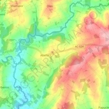
Name: Abellá topographic map, elevation, terrain.
Location: Abellá, Frades, Ordes, La Coruña, Galicia, España (43.06580 -8.33864 43.09911 -8.26750)
Average elevation: 1,168 ft
Minimum elevation: 935 ft
Maximum elevation: 1,447 ft
Thank you for supporting this site ❤️
Make a donation
Make a donation
Gear up for your next adventure:
As an Amazon Associate, this site earns from qualifying purchases at no extra cost to you.