Geolocate

Taras topographic map

Click on the map to display elevation.

About this map

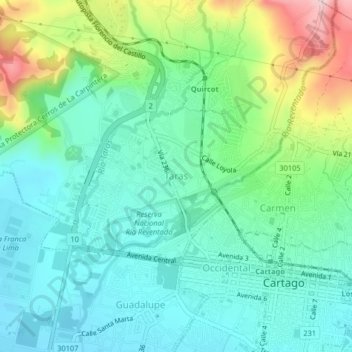
Name: Taras topographic map, elevation, terrain.

Location: Taras, San Nicolás, Cantón de Cartago, Cartago, 30104, Costa Rica (9.85636 -83.95287 9.89636 -83.91287)

Average elevation: 4,859 ft

Minimum elevation: 4,573 ft

Maximum elevation: 5,630 ft

Gear up for your next adventure:

🏫Relief Map Kits - Hands-on tools for teaching landforms and elevation
🪶Trail Camera - Capture wildlife on your hikes
🪶Camp Gear Gift Set - Perfect gift bundle for outdoor fans
🦶Carbon Trekking Poles - Reduce knee impact on steep descents with ultra-light poles
🌎3D Topographic Globes - Raised relief globes for a tactile understanding of geography

As an Amazon Associate, this site earns from qualifying purchases at no extra cost to you.