Geolocate

Hulsbeek topographic map

Click on the map to display elevation.

About this map

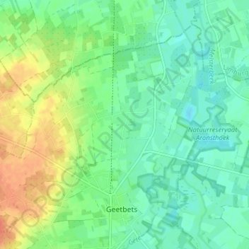
Name: Hulsbeek topographic map, elevation, terrain.

Location: Hulsbeek, Geetbets, Leuven, Vlaams-Brabant, 3450, België (50.88538 5.09527 50.92538 5.13527)

Average elevation: 105 ft

Minimum elevation: 56 ft

Maximum elevation: 194 ft

Gear up for your next adventure:

🩹Survival Bandages - High‑quality bandages for emergencies
🪶Trail Camera - Capture wildlife on your hikes
🪶LED Camping Lantern - Bright lantern for camp lighting
🛡️Insect Repellent - Protection against bugs during outdoor activities
🎒Day Hiking Backpack - Lightweight backpack perfect for day trips and outdoor adventures

As an Amazon Associate, this site earns from qualifying purchases at no extra cost to you.