
Cumba topographic map
Click on the map to display elevation.
About this map
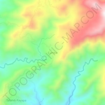
Name: Cumba topographic map, elevation, terrain.
Location: Cumba, Batangas City, Batangas, Calabarzon, Philippines (13.66256 121.11797 13.70256 121.15797)
Average elevation: 1,138 ft
Minimum elevation: 276 ft
Maximum elevation: 2,408 ft
Other topographic maps
Click on a map to view its topography, its elevation and its terrain.
Soro-soro Ibaba RWSA
Philippines > Batangas > Batangas City > Sorosoro Ibaba
Average elevation: 371 ft