
Thank you for supporting this site ❤️
Make a donation
Make a donation
Gear up for your next adventure:
As an Amazon Associate, this site earns from qualifying purchases at no extra cost to you.
Jamestown topographic map
Click on the map to display elevation.
Thank you for supporting this site ❤️
Make a donation
Make a donation
Gear up for your next adventure:
As an Amazon Associate, this site earns from qualifying purchases at no extra cost to you.
About this map
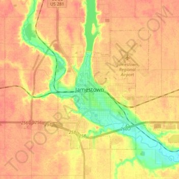
Name: Jamestown topographic map, elevation, terrain.
Location: Jamestown, Stutsman County, North Dakota, United States (46.87739 -98.75867 46.94292 -98.61514)
Average elevation: 1,480 ft
Minimum elevation: 1,371 ft
Maximum elevation: 1,535 ft
Stutsman County trails, hiking, mountain biking, running and outdoor activities
Thank you for supporting this site ❤️
Make a donation
Make a donation
Gear up for your next adventure:
As an Amazon Associate, this site earns from qualifying purchases at no extra cost to you.