
Thank you for supporting this site ❤️
Make a donation
Make a donation
Gear up for your next adventure:
As an Amazon Associate, this site earns from qualifying purchases at no extra cost to you.
Bölkum topographic map
Click on the map to display elevation.
Thank you for supporting this site ❤️
Make a donation
Make a donation
Gear up for your next adventure:
As an Amazon Associate, this site earns from qualifying purchases at no extra cost to you.
Bölkum
Der Weiler liegt in einer Höhe von 240 m ü. NHN auf den Hängen des Bergischen Landes. Nachbarorte sind Stranzenbach im Nordosten, Hodgeroth im Südosten und Röttgen im Nordosten.
Thank you for supporting this site ❤️
Make a donation
Make a donation
Gear up for your next adventure:
As an Amazon Associate, this site earns from qualifying purchases at no extra cost to you.
About this map
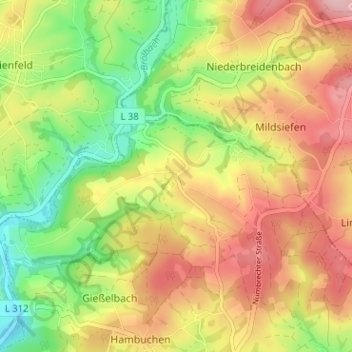
Name: Bölkum topographic map, elevation, terrain.
Average elevation: 741 ft
Minimum elevation: 466 ft
Maximum elevation: 1,007 ft
Thank you for supporting this site ❤️
Make a donation
Make a donation
Gear up for your next adventure:
As an Amazon Associate, this site earns from qualifying purchases at no extra cost to you.