Geolocate

Botong topographic map

Click on the map to display elevation.

About this map

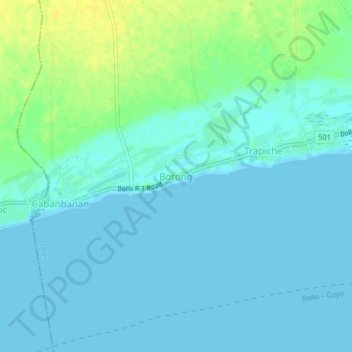
Name: Botong topographic map, elevation, terrain.

Location: Botong, Oton, Iloilo, Western Visayas, 5020, Philippines (10.66558 122.41827 10.70558 122.45827)

Average elevation: 16 ft

Minimum elevation: -7 ft

Maximum elevation: 66 ft

Other topographic maps

Click on a map to view its topography, its elevation and its terrain.

Savannah Subdivision

Philippines > Iloilo > Oton > Abilay Norte

Average elevation: 52 ft

Iloilo River

Philippines > Iloilo > Oton > Pakiad > Linstle Ville

Average elevation: 16 ft

Gear up for your next adventure:

🪶Camping Sleeping Pad - Comfortable sleeping pad for backpacking
🪶Trail Camera - Capture wildlife on your hikes
📦Dry Bags Set - Waterproof storage for electronics and clothes
🧦Merino Wool Socks - Moisture-wicking, blister-preventing socks for long treks
🦟Ultrasonic Repellers - Create a bug-free zone at your camp or rest stop

As an Amazon Associate, this site earns from qualifying purchases at no extra cost to you.